The tree at the bottom of the world—and the wind-blasted trek to find it
- 2020年8月24日
- 讀畢需時 14 分鐘
Resource: National Geographic
by CRAIG WELCH
Photographs by IAN TEH
Where on this warming planet, you ask, is the southernmost tree? Look no further: National Geographic sent a team to hunt it down.
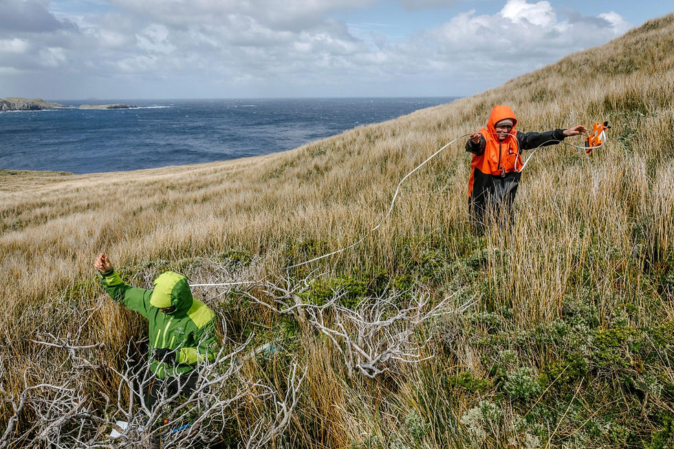
Searching for the southernmost tree on Earth, scientists traverse a dense thicket of forest and brush along a wind-swept plateau on Cape Horn island, near the tip of South America.
TO BE UNIMPRESSED at first glance is entirely reasonable. It’s just a tangle of gnarled limbs and silver bark hidden by reedy grass.
Seven trees sprout on a hillside near the southern tip of South America, above the treacherous swirl of spray where the Pacific Ocean meets the Atlantic. A few of them are dead. None reaches higher than my thigh. The living bend and curl their way a dozen feet across the ground, like soldiers clawing through battlefield mud. Furious winds have driven their trunks completely horizontal.
It’s hard to square these scraggly specimens with the exceptional lengths we’ve gone to find them. We’ve flown across oceans; chugged 32 hours by ferry; motored 10 hours more on a wooden charter boat captained by a sailor who confessed mid-journey that he’d never navigated this deadly stretch of sea. Only then did we reach our destination—Isla Hornos, Cape Horn island, the last spit of ground in Tiera del Fuego. There we’ve hiked and camped through gales that knocked us down, slipped on penguin guano, and vanished to our armpits in thickets of barberry.

Looking for trees where the Atlantic meets the Pacific, ecologists Brian Buma (with binoculars) and Andrés Holz scan the grassy ledges of Cape Horn’s headwall, the southernmost point on the island.
We’ve come all this way to map a border no scientist has mapped before. We’ve come to find Earth’s southernmost tree. (To learn more about the epic odyssey to find the tree at the end of the world, listen to the latest episode of our podcast, Overheard at National Geographic.)
“This is it,” says Brian Buma, a forest ecologist from the University of Colorado, Denver. He’s draped head to toe in orange and black rain gear. Straddling hummocks, he re-checks his compass and mutters “cool.”
Few things in the natural world can be identified as the true end, the last of a kind, the edge, Buma tells me. He pulls a measuring tape from his daypack and starts appraising a recumbent trunk, one just a few inches south of the rest.
“It strikes me that we should know where these things are,” he says.

In the 21st century it can seem
as if there are no places we’ve not surveyed down to the last inch. We take selfies on the world’s tallest mountain, pilot submarines to the oceans’ deepest trench, explore the planet’s driest deserts. But we’ve never identified—at least not correctly—the final stands of trees at the top or bottom of the world.
Now forests are on the move. As the climate warms, tree lines are moving higher up mountains all over the planet. Tree species also are extending their ranges toward higher latitudes; scientists have documented this poleward march in Europe, the Canadian Rockies, and across China. As trees move, ecosystems change. In Alaska, longer growing seasons now let willows get so big they poke through snow in winter. That has drawn moose and snowshoe hares from the Brooks Range all the way to the Arctic Ocean. The Arctic and parts of Antarctica are the fastest-warming regions on Earth.
But most of what we know about these grand ecological shifts comes from research north of the Equator. The global south, Buma says, has been mostly neglected.
Thumbing through old botany books and explorers’ journals, he saw an opportunity: They contained a bewildering assortment of claims for the whereabouts of the global south’s last woods. If he could find the southernmost tree, it could become the focal point of a living laboratory that scientists could visit for years to come. They could set up equipment to monitor soil warmth and tree growth. They’d study the animals that lived in this ecosystem on the edge. And over time they’d be able to determine if that edge was moving.

Expedition leader Brian Buma waits aboard the 65-footOveja Negrabefore departing Puerto Williams, Chile, for Cape Horn island. Finding the southernmost tree, he says, might help him track the advance of forests as climate change warms the planet.
But first Buma would have to find the tree. And finding anything in the archipelago that brushed back Charles Darwin and nearly broke Captain Bligh wouldn’t be a walk in the woods. Just getting near it would be hard enough.
Buma prefers science that mixes sleuthing with adrenalin, ideally in hard-to-reach forests in miserable conditions. Once, in Alaska’s Glacier Bay National Park, he kayaked icy fjords in pouring rain and pawed through head-high shrubs thick with brown bears—all just to locate some miniscule research plots no bigger than couch cushions that had been set up in 1916 by a botanist named William Skinner Cooper. The plots had become overgrown and gotten lost to science until Buma pulled Cooper’s hand-drawn maps from dusty archives. Now they provide a century-long record of how plants take over ground uncovered by retreating glaciers.
Buma recounts that adventure from a seat on the cargo ferry Yaghan. Along with photographer Ian Teh and a collection of old trucks and bed frames, we’re chugging through the Strait of Magellan beneath slate skies on a January afternoon in 2019. Outside, ice-blue glaciers spill down the flanks of the southern Andes. Macaroni penguins crowd boulders near the shore. We’re on a day-and-a-half-long run from Punta Arenas, Chile, to Puerto Williams, South America’s southernmost city. There we’ll rendezvous with a smaller boat.
Tall and sunburned in a flannel shirt and too-long canvas work pants, Buma is in high spirits—a detective off to untangle a new mystery. With a National Geographic Society grant, he and Chilean ecologist Ricardo Rozzi have assembled a crew that hopes to study the south’s terminal forest. One researcher will attempt to record bats. Two others will scale trees to study the canopy. An anthropologist plans to sift through sands for signs of early human settlement. And a small team will help Buma spot his tree.
Buma opens a sketchbook to a drawing of our destination. In the austral twilight it resembles a pirate map. Buma confesses he’d briefly considered hunting for the planet’s northernmost tree. It’s most likely a larch, almost certainly somewhere in central Siberia—but that’s too large a region to search in a single expedition. He wanted to be certain, Buma says, “we could find an answer and be sure we were right.”

On the ferryYaghan, Chilean ecologist Ricardo Rozzi pores over a map. Rozzi had spotted trees on Cape Horn during a previous journey but had never attempted to map them or locate the southernmost specimen.
In the Southern Hemisphere, there’s far less ground to cover. Antarctica was forested tens of millions of years ago during the Eocene Epoch, when the planet was warmer, but no trees live there now. The ocean around it is dotted with islands, and some sprout rushes, forbs, and grasses—but no trees. The islands have been surveyed repeatedly since Captain James Cook pronounced South Georgia Island “treeless” in 1775.
Scouring the Internet, Buma found claims literally all over the map. One website suggested the world’s southernmost tree was on Navarino Island, where Puerto Williams is, a hundred miles north of Cape Horn; another put it on Hoste Island, 35 miles north of the cape. A journal article from the 1840s, based on a dispatch from botanist Joseph Dalton Hooker, who sailed with the HMS Erebus and Terror, concluded confidently: “Hermite Island may be considered the most southerly spot on the globe where anything like arborescent vegetation is to be found.”
But Hooker never visited the island just south of Hermite, the one rendered in pencil in Buma’s sketchbook: Cape Horn island itself, a place Wikipedia dubs “entirely treeless.” Why would there be trees on Hermite but none on Isla Hornos, just a few miles away? Buma wondered. When he made his case to Rozzi, the Chilean was enthusiastic. Rozzi “was like, ‘Oh yeah, I’ve been there,’” Buma recalls. “‘There are trees.’”


The dagger peaks of the Dientes de Navarino mountains draw tourists to Puerto Williams, on the Beagle Channel. Many take the ferry from Punta Arenas, chugging past icy fjords through the moonlit waters of the Strait of Magellan.
In Puerto Williams, where Rozzi oversees a research station operated by the University of Magallanes, we load our gear onto the Oveja Negra, the “Black Sheep.” The 65-foot cruiser fashioned from cypress is piloted by Rozzi’s frenetic, wild-haired nephew Ezio, a former chef. Soon we’re cutting south through Beagle Channel, named for Darwin’s ship. The captain bubbles with excitement—“I’ve never rounded the Cape!” he shouts. My stomach groans.
The Cape is a massive prow, a knobby 1,300-foot-high headland that plunges directly to the sea from the southernmost flank of Isla Hornos. South of there lies a band of ocean that stretches uninterrupted around the planet. Furious westerlies drive the sea surface into giant rollers called greybeards. When those huge waves hit the shallow continental shelf, just off the Cape, they produce some of the planet’s most disorderly and menacing seas. Now and then icebergs wander in on foaming waters.
For centuries, sailors have died “rounding the Horn,” especially moving east to west against the winds. In 1788, before his crew’s infamous mutiny, William Bligh of the HMS Bounty failed for a month to negotiate this turn. In 1832, “great black clouds” unleashed “extreme violence” and beat back Darwin.
As we head for the Cape, Buma opens his notebook to a sketch of the promontory. The most southern spot where his tree could be is there, springing from a ledge hundreds of feet up, he says. That’s why he brought ropes, climbing gear, and John Harley, a seasoned mountaineer. Harley’s prepared to lead us to it, if necessary. “It could be fun,” Buma says. I’m not sure I agree.
Ten hours from Puerto Williams, the rain comes out of suddenly darkening skies. The captain is nervous. A real rager is on its way, but we’re finally off the east flank of Isla Hornos. While Ezio considers ducking into a sheltered bay, Buma tells us to get ready. If we don’t make land now, we could be stuck onboard for days.

With storm clouds on the horizon, an inflatable Zodiac ferries expedition members and their gear from the Oveja Negrato a narrow beach on Cape Horn island.
An hour later, backpacks stuffed, we file into small inflatable boats and motor to a shallow beach below a bluff. This is not terra incognita: After climbing 160 makeshift steps we reach a short boardwalk that leads to an old church and a lighthouse manned by a Chilean Navy officer and his family. A few steps beyond is a metal albatross, a memorial to those who’ve died at sea. On clear mornings a few months a year, cruise ship passengers disembark here. Most stay an hour or less.
But none venture where we’re headed. The Chilean government keeps the bulk of this island off limits, in part to protect rare endemic plants. Aside from a select few research expeditions, virtually no one has ventured beyond this soggy sliver in half a century.
Isla Hornos, at 10 square miles, is shaped a bit like a beetle. A prominent ridge runs north to south, ending in a horseshoe-shaped bay. The western arm of the horseshoe rises to the top of the Cape headwall. The other curls east to the lighthouse. By late afternoon, we’re ducking into the wind and trudging uphill in rubber gum boots along that eastern flank, aiming for a spot three miles west.
At first, the walking is easy. But as the land rises the grass gives way to gnarled, head-high shrubs of holly-leaved barberry and prickly heath. Dense witch-fingered branches make passing between them almost impossible. So we step onto the brush itself.


Chilean navy officer Andrés Morales is stationed alone with his family on the eastern shore of Cape Horn island, in a lighthouse overlooking Drake Passage. He provides weather reports to passing ships. The lighthouse is adjacent to an old chapel, where some expedition scientists take refuge from the cape’s wind and rain.

Night after night, the same winds that drive deadly tall waves just offshore force team members to hunker down for meals sheltered by shrubs and patches of dwarf forest.
Moving gingerly, we lurch from one tangle of boughs to another. Over time we rise higher up the shrubs, to keep branches from snapping against our cheeks. I travel hundreds of feet this way, boots never touching ground. Occasionally, one foot plunges past waxy leaves to my shin as if breaking through a snow bridge across a crevasse. A few times I fall nearly to my waist.
We reach a wind-scarred plateau. My rippling jacket sounds like a roaring engine against the howling gusts. We have to shout to be heard. Teh, the photographer, gets blown off his feet. It has taken an hour to move less than a mile.
Starting down the west side, we step still higher into the shrubs. Eventually we’re crunching delicately across the very tops of the barberry. The vegetation is so thick it’s not clear whether the ground is five feet below or 15. I crash through branches to my throat and have to wait for Teh to pull me free.
At sea level, the brush opens enough for us to glimpse sharp ditches, most of them thigh deep, slopped with what we assume is mud. Then we hear a yelp and someone shouts, “Penguins!” Magellanic penguins have tunnels beneath the brush and are racing underfoot through these poop-streaked channels to their colonies.

The brush and trees are so thick in places that researchers must move gingerly through and atop the vegetation to avoid sliding in mud into a steep ravine.
Finally, we hit a wide, brush-free meadow. Setting up camp, I spy Buma staring west. Up a barely visible slope, I make out branching canopies above silver bark—the planet’s southernmost woods.
Every day for the next 10, scientists emerge from our half-dozen tents and scatter. A Texas researcher scours thin streams for insects. A Chilean ornithologist uses fine mesh nets to catch finches and snipes. Buma, Harley, and Andrès Holz, a Chilean-born forest ecologist from Portland State University, tramp over spongy bogs and mounded cushion plants, looking for trees.
It’s not as straightforward as it sounds. There is no widely accepted scientific definition of a tree. The U.S. National Park Service, for example, claims trees generally are at least 20 feet tall—but that excludes varieties of magnolias and maples, almonds and junipers that we all clearly consider trees. Buma’s team uses a more intuitive definition, one that most of us would agree with: A tree is a perennial plant with a single woody trunk and few or no low branches—whereas shrubs have multiple trunks and low branches.
On Isla Hornos, the researchers identify three species: a rare winter’s bark, and two common southern beeches. Elsewhere these evergreens can rise 65 feet. Here those most protected from wind may reach 30 feet. Most, though, do not. Entire stands aren’t much taller than I am.

Magellanic penguins skitter onto the rocky shores of Cape Horn after a day of fishing. Scientists often heard the birds racing to and from their colonies through muddy channels beneath the shrubs.
These dwarf forests are scattered in patches beneath a ridgeline southwest of our camp. After days exploring their perimeter, it’s clear that locating the southernmost individual won’t be easy. If it sprouts from the Cape headland we’ll need clear skies to scan the wall—then winds slow enough to climb up or rappel down it. But this is one of the hemisphere’s stormiest places.
The last tree also could be at the forest’s edge. But it’s more likely to live off alone or in a small cluster, and we may have to comb the ground to see it. A tree by itself wouldn’t stay vertical for long against the Cape’s gusts. It would be “struggling to get its head up above all those shrubs,” Holz says.
During our stay, gusts hit 75 knots—the bottom rung of the hurricane scale. The wind shreds one tent and nearly blows another into the sea. We dry clothes on our back by “stationary sailing”—spreading arms and legs and turning into the breeze.
We tackle tasks based on weather windows. One overcast afternoon, we venture into a stubby grove to gather data. The canopy is so thick and short we drop to our knees and crawl. Inside, we find a mat of electric-green mosses and lichens. Above, each tree is bent and bowed in squat spirals like coiled springs. It feels like a world created by J.R.R. Tolkien and compressed from above by a giant hand. I watch the scientists measure trees and map plots to revisit later.

Tree canopy researcher Iván Díaz ascends some Magellan's beech trees that, tucked against a slope and protected from the wind, have grown unusually tall for Cape Horn island. Most of the island's trees aren’t much bigger than Díaz himself.
That evening, Holz shares his surprise at the island’s lushness. It belies the harsh conditions. Coring several trunks, he found their rings nearly white, a sign of explosive growth. “These are very happy trees,” Holz says—not what he’d expected from such an extreme environment.
When the mist finally lifts one morning, we hike up the Cape headland and peer straight down over the cliff. We scan the glistening ledges and crevices for trunks and saplings. We see nothing, but the angle makes it impossible to rule out arborescent vegetation.
So, more than a week into our stay, on the first sunny dawn, we radio the Oveja Negra. After piling again into Zodiacs and clambering back aboard, we putter near the Cape for the first time. Buma, intrigued by the idea of surveying the last tree while dangling from a rope above the roughest seas on Earth, still hopes his quarry is here.
We bob in swells a few hundred yards east, scoping the rock from the bow. Even from here I can see the breakers smashing below the face. Behind me, Buma sways gently, binoculars up. He still sees no trees.
“Way at the top—that’s all grass?” Harley shouts.
“Just a lot of grass,” Buma confirms.
Buma turns to me. “But we haven’t looked at it all yet.”
To do that we’ll have to round the Horn ourselves. The captain turns our craft and prepares to make the treacherous run. In the distance we see white caps building. We face the waves and slam through. Ezio, wild-eyed, begins to hoot. The winds pick up, and the boat begins to shimmy. Someone scrambles below deck and gets sick.
Within minutes, Ezio is turning back around. We’ve seen what we needed. But he’s eager to pilot us back to smoother waters. Above us the rock’s wet ledges are draped with vegetation. But it’s clear there is no tree. To my relief, the carabiners and ropes Harley carted halfway around the world won’t be needed after all.

On January 25, 2019, Buma, left, and Holz find and identify the world’s southernmost tree, a Magellan's beech. Bent by the wind, it rises to a height of roughly three feet before turning horizontal and growing a dozen feet along the ground.
Back on land, Holz and Buma resume their search in earnest. Now that they know the cliff itself is out, they march a grid pattern along the slope behind it.
Two days later, on January 25, Buma finds his tree: a snarl of branches poking through clumpy tussock grass. He checks his GPS device and, while I stand next to the tree, walks another grid and finds the next closest tree, 17 meters, or 56 feet, to the north; a half-acre forest is hundreds of yards beyond that. Using me as a marker, he takes readings from both a handheld and digital compass to confirm that the first tree is indeed the furthest south.
Buma and Holz dig in the grass. Instead of a single tree they count seven trunks, only some of which are living. The survivors, though, appear healthy. The scientists circle the trees and start chattering.
“We're on a northeast-facing slope, which is probably the best place to be a tree here,” Buma says.
Holz adds, “It’s getting the sunlight and a bit of shelter from the wind.”
“Diameter-wise, it's a legitimately large tree,” Buma says.
The tree is a Nothofagus betuloides, Magellan's beech, a type of tree first collected by Captain Cook’s team. Tree rings place its age at 41 years. Its diameter is 10 centimeters, or four inches. It stands about three feet high. From there it bends sideways and grows through the grass.
It’s no towering redwood or sprawling oak. But Buma is all smiles. “This is absolutely amazing,” he says.
The southernmost tree is one of a stand of seven beech trees, a few of which are dead. As the planet warms, will forests expand south toward Antarctica? Scientists now have a baseline against which to track their progress.
Aboard the Oveja Negra a few days later, we’re cutting back across a placid Beagle Channel. The waters are so calm we’re guided for a spell by dusky dolphins. After 11 days of pounding wind and rain and squeezing three of us into a two-person tent, I’m ready for a beer and a hot shower. Buma, though, is still giddy. In a small way, he and Holz have made history. Their work has established a scientific baseline to measure forest migration. It’s also just kind of cool.
Earlier Holz had noted his surprise at how fast Cape Horn’s trees are growing. Less clear is whether that’s how it’s always been. How much has this place already changed as the planet has warmed? We can’t say for sure. But Buma and Rozzi, in Chile, will be able to track what happens next. How different will it look in 20 years? Will this tundra-like landscape eventually become one rich forest? Will winds altered by a shifting climate move the forest’s edge? As the region grows hotter might birds one day ferry seeds to the Diego Ramirez Islands, 65 miles southwest of here, letting trees take root in places that are now treeless?
Climate change can seem abstract, Buma says, but even school kids can understand this process. He can show them a speck on Google Earth that contains this southernmost tree, and it becomes more tangible and meaningful.
“The idea has always been, let’s find a point, a physical point that people can see, that marks the edge,” he says. Then we can all watch the planet move beyond it.
This story and the expedition were supported by a grant from the National Geographic Society.
Ian Teh lives in Kuala Lumpur, Malaysia. He is a Pulitzer Center grantee examining the changing landscapes affected by development and climate change on China’s Yellow River.

加入LINE詢問相關資訊
掃描APPLY QRCode填寫申請表!
更多精彩內容,請持續關注教育商城,
歡迎前來諮詢申請!


留言